Lithium Investment Opportunity
Project SOM-BOS DW Brownfield
Our company has three distinct functions, as follows.
1. investing capital into sustainable junior strategic minerals projects, mostly in Africa.
2. provision of metallurgical and mineralogical consultancy services, including feasibility studies on Greenfield and Brownfield Projects.
3. Trading in and conversion of processed minerals and their downstream added value metal products, primarily in the “3T metals “, Tantalum/Niobium, Tin & Tungsten, but also in Copper, Lithium, Manganese & Platinum Group Metals.
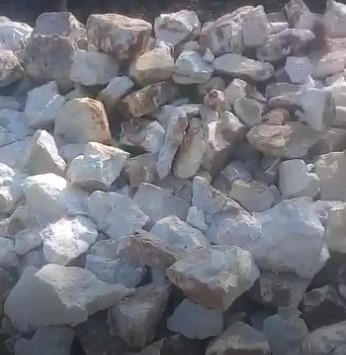
The attached pages represent project desktop geology to date, which we have added to via recent site visits, which illustrate considerable presence of lepidolite.
As you will be well aware, until relatively recently historically Lithium had few bulk applications, so when areas were primarily mined, Lithium bearing strata was removed in order to access other minerals such as cassiterite/coltan etc.
This Somaliland area was thus developed in the same manner, which means the Lithium bearing mineral is still present on a “brownfield “basis and available for us to process and develop. Our geologists consider that the area may well have additional greenfield reserves
We have existing markets for the cassiterite and coltan generated from the area, so we are seeking to cooperate with any potential South Korean company with a view to committing all the minerals to a venture between our parent company subsidiary in Somaliland and Korean company, to mutual long-term benefit.
We also have a further Somaliland region and 2 other African country Lithium reserves available to us, on which we could cooperate with potential South Korean companies, can provide details on those, dependent on their interests.
Majahayan - Dalan Tin Deposit Review and Recommendations
1.0 Introduction
The Majayahan - Dalan area is located in North-East Somaliland in the semi-autonomous region of Puntland, approximately 30 km SE of the major seaport, Bosaso. It was initially mined for Sn (tin) during World War 2 by Italy. The mineral deposits are on territory traditionally belonging to the Warsangeli Clan, who are neither affiliated with Somaliland or Puntland, but rather the area in North-East Puntland and the northern Sanaag region in Somaliland. Past conflicts have arisen when the Puntland government has tried to bring in external mining companies to exploit the tin resources without permission of the Warsangeli.
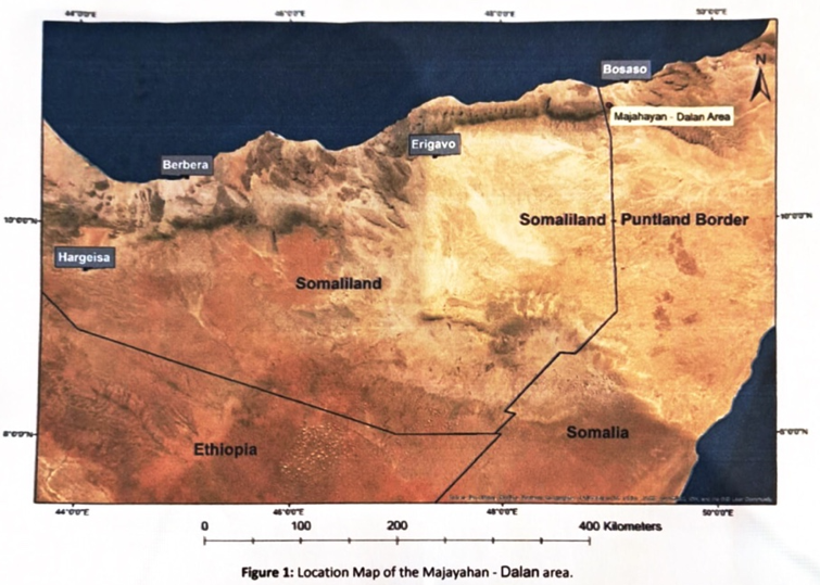
Figure 1: Location Map of the Majayahan - Dalan area.
2.0 Geological Review
As previously mentioned, the mines were initially exploited for Sn by Italy during the Second World War. In the 1950s, the British Geological Survey discovered Ta mineralisation and later continued further sampling work in 1961. The last significant commercial exploitation and exploration was conducted by Techno expert Bulgaria in the mid-1970s, where both Sn and Ta were mined.
Geological Model
The general geological model for mineralisation in the Majahayan - Dalan area is a mixture of granitic pegmatite intrusions and quartz veins intruding greenschist facies metasediments and metaigneous rocks. Both pegmatites and veins have the capacity to be mineralised for Sn, so it is possible that the veins are offshoots from the main pegmatite magma. The pegmatites are U-Pb dated to -530 Ma, relating to Pan-African orogenic formation. Rb-Sr muscovite ages show -465
Majahayan Interpreted Geological Map 1:50 000
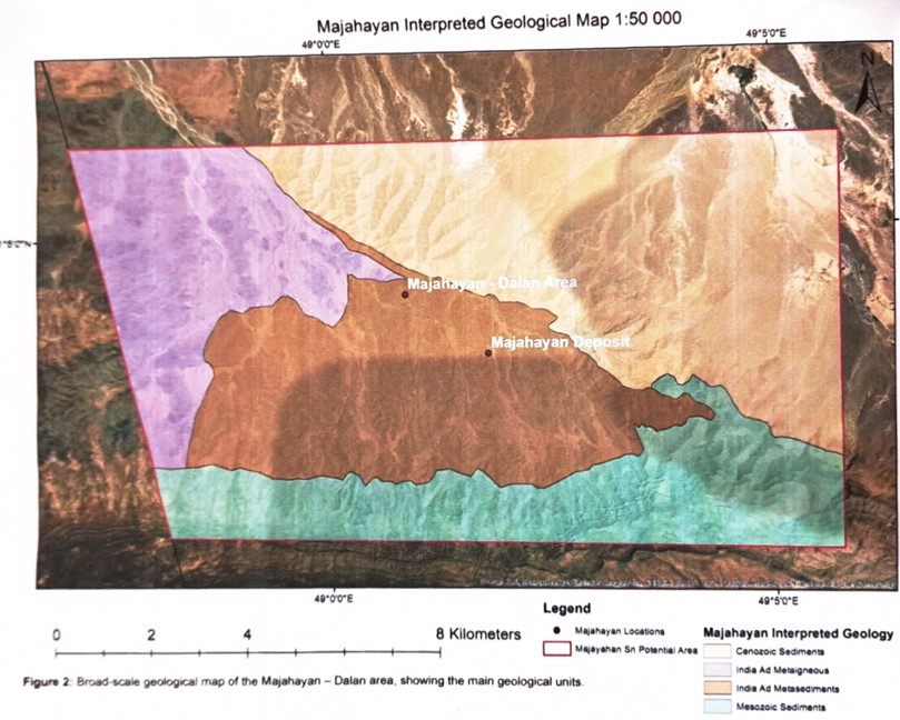
Figure 2: Broad-scale geological map of the Majahayan - Dalan area, showing the main geological units.
The mine workings and town development in Dalan area is very close to the interpreted border between the metasedimentary and metaigneous rocks of the India Ad formation. This could suggest the boundary between the two broad rock types is an exploration target, however, there is not nearly enough evidence to suggest this with any certainty.
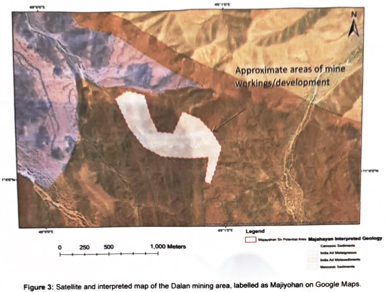
Figure 3: Satellite and interpreted map of the Dalan mining area, labelled as Majiyohan on Google Maps
At the Majahayan deposit, the satellite imagery shows the approximate surface exposure of the pegmatite, although it still may be present at shallow depths and not be shown properly on the imagery.
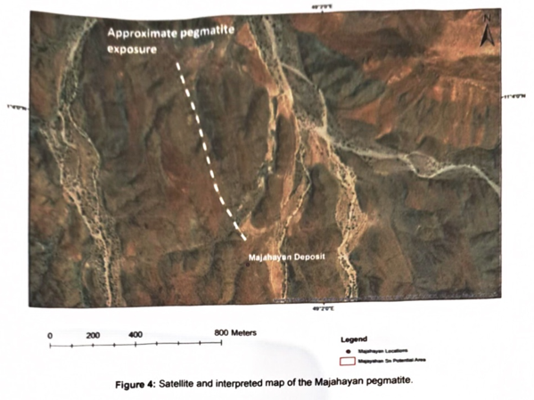
Figure 4: Satellite and interpreted map of the Majahayan pegmatite.
Satellite Imagery Explanation vs Other Areas
The satellite imagery is generally inconclusive for identifying and tracking the pegmatites and veins in the area, and does not show many small-scale details compared to other areas in Somaliland. Its main use in this area has been to roughly delineate the major rock boundaries and add little bits of context to any spatial data acquired.
Pegmatites and veins that are mined for any of Li-Sn-Ta-W are notoriously hard to explore for with remote methods as they are often buried beneath surface material and do not have many compositional and geophysical features that are different from their host rocks.
It is sometimes possible to identify them from satellite imagery if the exposure of the rock is good and the pegmatites are of a different cohesive strength (e.g., they have a different weathering speed to their host rocks), such as in the western region of Somaliland in the ASM exploration area. Despite this there is not have a way of identifying whether or not the pegmatite/vein hosts any metal until it is investigated on foot. Most of these pegmatites/veins are explored for using stream sediment sampling to track Be and the heavy metals (Sn-W-Ta-Nb) and are then traced upstream.
The reason why the satellite imagery was so useful in the Laasa-Surad area was due to the manganese showing distinctive maroon colouring on the satellite imagery, which made it possible to differentiate it from the surrounding rocks. Metals such as gold or copper are also usually associated with sulphides, which often exhibit a starkly different colour to the surrounding rocks as the fluids involved in this mineralisation is highly acidic and alters the surrounding rock (creating the localised colour variation). Of course, this is still only useful in areas where the rock exposure is visible. Ma, which is likely a re-setting event caused by addition of fluids, which may indicate age of metamorphism.
The Majahayan Deposit is a mixture of around 20 steeply dipping, < 1m thick pegmatites and quartz veins that cut schists of the India Ad series. The mineralogy in these pegmatites varies, with some showing a simple composition of quartz, K-feldpsar, muscovite ± albite with others displaying complex zonation with the addition of spodumene ± lepidolite, cassiterite, columbite/tantalite and tapiolite. The quartz veins contain mostly quartz, cassiterite and muscovite ± rutile, tourmaline and pyrite.
The Dalan area hosts a swarm of 30 sub-parallel quartz veins 50-130 m long and <7 m wide, which cut metagabbros and calcareous sandstone of the Inda Ad Series. The North-South set of veins is barren, whereas 100 of -250 veins that trend East-West carry some cassiterite. Most of the cassiterite came from relatively near surface, as irregular large clusters, occasionally more than 4 kg in weight. Pitting of the veins by geologists from the British Geological Survey in 1961 found no continuation of the mineralisation with depth, suggesting the cassiterite in this area is confined to near-surface greisenised zones. Accessory minerals include apatite, rutile, braunite, pyrolusite, tourmaline, pyrite, haematite and muscovite.
Cassiterite was formerly worked at Manja Yihin, near Bosaso. Numerous quartz veins and pegmatite dykes in the India Ad inlier, are orientated either North-Northwest to South-Southeast, or East-Northeast to West-Southwest. Both systems show cassiterite mineralization. This area is not known to have been commercially exploited.
Deposit Reserves
The Majahayan deposit has differing resource estimations, with one estimate of a resource of 200,000 tonnes at a grade of 0.074% tin, 0.011% tantalum, 0.98% rubidium and 0.036% caesium, and another centred around Ta of 1.6 Mt grading 0.018% Ta2O5.
The largest deposit in the Dalan area has estimated resources of 2.8 Mt at a grade of 0.028% tin, the second largest has estimated resources of 1.4 Mt at a grade of 0.129% tin, 0.015% tantalum, 0.132% rubidium and 0.011% caesium, and the smallest has an estimated resource of only 13,000 tonnes. The exact locations of the different Dalan area deposits are unknown.